Comprehensive Economic Development Strategy 2015 Annual Performance Report
An assessment of economic development activities of the North Central Wisconsin Regional Planning Commission over the last decade and the past year. The report’s seven sections describe the CEDS Committee, Past Year’s Activities, the Physical Region, Changes in the Region’s Population, changes in the Region’s Economy, a Regional Development Strategy, and an Economic Development Work Plan. Also included is a list of potential public works projects. This CEDS process maintains the Region’s eligibility as an Economic Development District (EDD) with the U.S. Economic Development Administration. The District consists of ten counties. These counties are Adams, Forest, Juneau, Langlade, Lincoln, Marathon, Oneida, Portage, Vilas, and Wood. However, Portage, and Wood Counties do not fully participate in the EDD – only some local communities with these two Counties participate.
Vilas County Farmland Preservation Plan 2015
In 2010, agriculture constituted a $59 billion industry in Wisconsin. Farmland around the country is being lost at an alarming rate, and, once it is gone, we cannot get it back. Farmland preservation planning is crucial to preserve the agricultural land remaining in Wisconsin, because of the economic importance of agriculture in the State and the potential for loss of our agricultural land base.
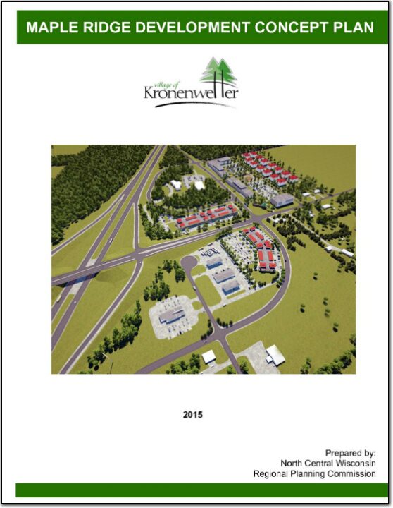
Maple Ridge Development Concept Plan
In the fall of 2014, the Village of Kronenwetter engaged the North Central Wisconsin Regional Planning Commission (NCWRPC) to evaluate development potential centered near I-39 and Maple Ridge Road. In 2013, the interchange located on Maple Ridge Road and I-39 was rebuilt by the Department of Transportation resulting in new infrastructure and development opportunities for the area.
Lincoln County Comprehensive Plan 2012-2021
The Lincoln County Planning & Zoning Department appreciates the involvement of various community stakeholders in the creation of new Transportation, Housing, Agricultural and Natural Resources, and Economic Development plans for the county. The names and organizations of those persons participating in the planning processes are included in the appropriate section of this comprehensive plan.
NCWRPC News Winter 2015 – Issue 55
Langlade County Farmland Preservation Plan 2014
In 2010, agriculture constituted a $59 billion industry in Wisconsin. Farmland around the country is being lost at an alarming rate, and, once it is gone, we cannot get it back. Farmland preservation planning is crucial to preserve the agricultural land remaining in Wisconsin, because of the economic importance of agriculture in the State and the potential for loss of our agricultural land base.
Langlade County Land and Water Resource Management 2015-2019
The Langlade County Land and Water Resource Management Plan is drafted as a 5-
year plan (2015-2019) with a 5-year Work Plan (2015-2019) in accordance to the
requirements set forth in Chapter 92 of the Wisconsin Statutes.
Marathon County Transportation Program Needs Assessment – 2014
The Marathon County Transportation Coordinating Committee (TCC) is responsible for the elderly and disabled transportation in the County. The TCC has determined it wants a better understanding of what the needs are for transportation for these groups across the County. This Needs Assessment is intended to compile information the TCC can use to begin to make decisions as to whether they have, at least at the County level, the ability to meet some of the needs that are out there and do some things where those needs might occur.
Vilas County Land and Water Resource Management 2015-2024
The Vilas County Land and Water Resource Management (LWRM) Plan is drafted as a 10-year plan (2015-2024) with a 5-year Work Plan (2015-2019) in accordance to the requirements set forth in Chapter 92 of the Wisconsin Statutes.