Providing Economic Development, Geographic Information Systems, Intergovernmental Cooperation, Land Use Planning and Transportation Assistance since 1973
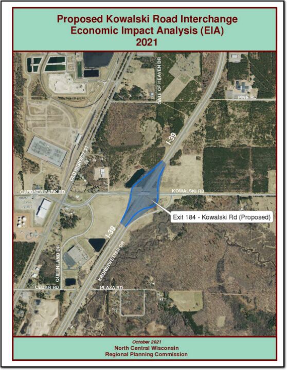
An economic impact analysis was completed by the North Central Wisconsin Regional Planning Commission to answer the question, what would be the economic impact of the proposed interchange at Kowalski Road and Interstate 39 in the Village of Kronenwetter.
With assistance from a WisDOT planning grant, the Forest County Potawatomi Community (FCPC) was able to develop a comprehensive bicycle and pedestrian plan to enhance the viability of bicycling and walking as forms of transportation throughout the Forest County Potawatomi Community. The planning project occurred from October 2019 and continued into the Summer of 2021 with a signifi cant delay resulting from the COVID-19 pandemic. The process included data analysis, conceptual planning, public outreach, development of a preferred routing, and detailed cost estimating.
Wood County is a county located in central Wisconsin. As of the 2020 census, the population was 74,207. The county seat is Wisconsin Rapids. Wood County was created in 1856 and is named after Joseph Wood, who was a Wisconsin State Assemblyman. The county is known for its many lakes, rivers and outdoor recreational opportunities, including the Wood County Parks, the Wisconsin River and the Ice Age Trail. The county is home to the city of Wisconsin Rapids, which is the county’s largest city and the regional center for commerce, industry, healthcare, and education. The county also has several small towns and communities, including Marshfield, Nekoosa, and Port Edwards. The county has a diverse economy, with healthcare, manufacturing and service industries being the main drivers. The county is also known for its paper mills, which have been a staple industry in the area for many years.
Vilas County is a county located in northern Wisconsin. As of the 2020 census, the population was 23,047. The county seat is Eagle River. Vilas County was created in 1893 and is named after William Freeman Vilas, who was a U.S. Senator from Wisconsin. The county is known for its many lakes, forests, and outdoor recreational opportunities, including the Vilas County Parks, the Eagle River Chain of Lakes and the Nicolet National Forest. The county is home to the city of Eagle River, which is the county’s largest city and the regional center for tourism and recreation. The county also has several small towns and communities, including St Germain, Conover, and Boulder Junction. The county has a strong tourism industry, with many visitors coming to the county for fishing, hunting, boating and snowmobiling.
Portage County is a county located in central Wisconsin. As of the 2020 census, the population was 70,377. The county seat is Stevens Point. Portage County was created in 1839 and is named after the Fox-Wisconsin Waterway, a historic portage route used by Native Americans and European settlers. The county is known for its many lakes, rivers, and outdoor recreational opportunities, including the Tomorrow River State Trail, the Wisconsin River and the Ice Age Trail. The county is home to the city of Stevens Point, which is the county’s largest city and the regional center for commerce, industry, healthcare, and education. The county also has several small towns and communities, including Plover, Rosholt, and Amherst. The county has a diverse economy, with healthcare, manufacturing, and service industries being the main drivers.
Oneida County is a county located in northern Wisconsin. As of the 2020 census, the population was 37,845. The county seat is Rhinelander. Oneida County was created in 1887 and is named after the Oneida Nation, which is a tribe of the Iroquois Confederacy. The county is known for its many lakes, forests, and outdoor recreational opportunities, including the Oneida County Forest, the Wisconsin River and the Nicolet National Forest. The county is home to the city of Rhinelander, which is the county’s largest city and the regional center for commerce, industry, healthcare, and education. The county also has several small towns and communities, including Three Lakes, Minocqua, and Hazelhurst. The county has a diverse economy, with tourism, manufacturing, and service industries being the main drivers.
Marathon County is a county located in central Wisconsin. As of the 2020 census, the population was 138,013. The county seat is Wausau. Marathon County was created in 1850 and is named after the Marathon race of ancient Greece. The county is known for its many lakes, rivers, and outdoor recreational opportunities, including the Marathon County Parks, the Eau Claire River, and the Ice Age Trail. The county is home to the city of Wausau, which is the county’s largest city and the regional center for commerce, industry, healthcare, and education. The county also has several small towns and communities, including Mosinee, Rothschild, and Edgar. The county has a diverse economy, with healthcare, manufacturing, and service industries being the main drivers.
Lincoln County is a county located in northern Wisconsin. As of the 2020 census, the population was 28,415. The county seat is Merrill. Lincoln County was created in 1881 and is named after Abraham Lincoln, the 16th President of the United States. The county is known for its many lakes, forests, and outdoor recreational opportunities, including the Lincoln County Forest, the Wisconsin River and the Ice Age Trail. The county is mostly rural with paper mills and manufacturing being the main industries. The county has several small towns and communities, including Tomahawk, Merrill, and Gleason. The county is also known for its hunting, fishing, and snowmobiling.
Langlade County is a county located in northern Wisconsin. As of the 2020 census, the population was 19,491. The county seat is Antigo. Langlade County was created in 1879 and is named after Charles Langlade, a prominent fur trader and early settler in Wisconsin. The county is known for its many lakes, forests and outdoor recreational opportunities, including the Langlade County Forest, the Wolf River and the Ice Age Trail. The county is mostly rural with logging and paper mills as major industries. The county has several small towns and communities, including White Lake, Elcho, and Summit Lake. The county is also known for its hunting, fishing, and snowmobiling.
Juneau County is a county located in central Wisconsin. As of the 2020 census, the population was 26,718. The county seat is Mauston. Juneau County was created in 1857 and is named after Solomon Juneau, one of the founders of Milwaukee. The county is known for its rolling hills and valleys, as well as the Lemonweir and Wisconsin rivers. The county is home to the Castle Rock Lake, which is a popular spot for boating and fishing. Agriculture is the main industry in Juneau County, with dairy farming being particularly prevalent. Additionally, the county is home to several small communities and towns, including New Lisbon, Elroy and Necedah.